The Northeast Cambodia loop takes us from Phnom Penh to Kampong Cham, followed by Kratie, Stung Treng, Ban Lung (Ratanakiri), Sen Monorom (Mondulkiri) and Prey Veng before bringing us back to Phnom Penh. It is best to plan at least seven days for the trip. In order to ride at a reasonable pace with adequate time for sightseeing, I would suggest planning ten days for the loop. Personally, I spent nine days for the trip, with the last 2 days in Phnom Penh. The total distance I traveled was around 1500km.

Map of Cambodia and route taken
The roads near Phnom Penh are in good condition. However, these tarmac roads gradually deteriorate into dirt and gravels as you traveled further away from Phnom Penh. Of course, the Death Highway between Banlung and Sen Monorom is on another level altogether. But with the road constructions that have been going on around Cambodia, things might improve in the near future.
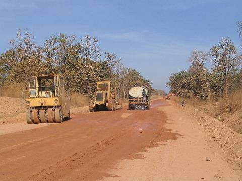
Road building in earnest
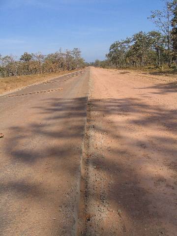
I wonder if every vehicle will try to keep to the left lane
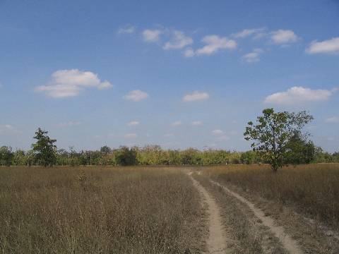
Better part of the Death Highway
In Cambodia, it is easy to know that you have arrived at a major town or city. In almost all the towns and cities I have visited, there is always a monument with a roundabout. It also serves as a good point of reference for us to get our bearings.
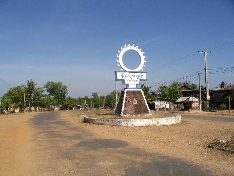
Monument with roundabout
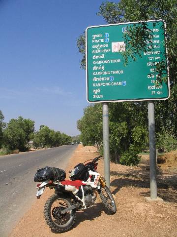
As usual, you will find helpful road signs and kilometer stones along the way.
You should not have problems finding petrol in Cambodia. If you do not see petrol stations in villages, you can still find stalls by the road sides selling bottled petrol. Remember to top up your tank whenever you can, especially if you are not sure of the distance to the next village.
Since I brought along my Garmin GPS receiver during this trip, I tracked my routes and took down my waypoints. If you would like a copy of the files, just post a comment and I will send the download link to your email. The size of the file is around 1.7MB.
I’d like to take the same tour in Cambodia and would love to have your GPS tracks and waypoints. Thanks,
Barry
Ok, sent.
Excellent journey…looking to do similar east cambodia route but coming from laos side.. appreciate if you can email me the waypoints..cheers bro
Hi khassan, link is sent to your email.
Hi!
Nice trip. Planning to do pretty much the same one in a couple of weeks and I would love to have your GPS waypoints
Thanks Chris
You web page is a big help; thanks so much for sharing! Please send me a link to those GPS waypoints.
Sent 🙂
hey wanting to do same trip heading over to phnom phen in oct and we are heading up that way, would love your way points
Thanx
i agree with rick your webpage is very helpful cheers mate
Sent!
Hi,
I just have bought a GPS it has been set to the same as the Matt J Adventure Cambodia book, is yours set the same?
I will cycle Rat. to Mon. next month. I am very fit, I cycled Batabong to Kho Kong last week through the Cardomen mountains. But my friend who is coming with me this time is not so fit. She wants to know more info. e.g is it steep etc.
I live in Rat. I know from Rat. to Lumpat is flat/down hill ) I have cycled there 2 times), and that will be our easy day 1. Day 2 will be to the next town, how far is it ?is that flat or up hill, can we buy water on the way? Then day 3 to Sen (something) in Mon. I know this is a gravel track is the up hill? how far is it ?Can we buy water on way. Thank you this info. would be very handy. tar
And also I would love you GPS way points.
best wishes
Tania
Thank you
Hi, I am heading out on this very trip this week. I have a Garmin as well and would very much like your GPS points. Back in January I took a Cardamum Mountain trip. Tried to make it from Koh Kong to Kampong Speu via Route 42. Local Villagers insisted that it could not be done!
Tania- Did you use the GPS for the Batambang to Koh Kong trip? Did you have guide or use Mr. Jacobson’s description for the trip? Did you go down through Pailin or Pursat? I would very much like your GPS track.
thanks
Tania,
So far, one person commented that my GPS points for Laos are slightly off. I did add a few GPS points from Matt’s book. But I didn’t follow it religiously. His road instructions are usually good enough.
I do not think you can cycle from Lumphat to Koh Nhek in one day. The route was quite isolated and there were almost no human settlements along the way, let alone finding shops that sell water. Do check out gt-rider forum for the latest information.
This is SO helpful. I’ve been trying to find out how to get up to the NE and actually extended my trip because of the long travel time. I would love the GPS points.
Hi Jenn,
Link sent to your mailbox.
Hi Atticus,
great reports and impressive pics. Thx.
I did the Northern Vietnam loop in 1993 and 1995, I drove a motorbike from Phnom Penh to Siem Reap in 2003, and now, just in 3 weeks, I will try to hit the tracks in NO Cambodia.
And I would love to use your GPS-tracks.
Thx,
Bensen
Hi Bensen,
I wonder what’s it like riding in northern Vietnam in the 90s. Russian Minsks should be pretty new but the roads must be quite rough? 🙂
Anyway, link sent to your mailbox.
Would love to get the GPS data you mention!
Steve,
Sent!
Hey bro, please send it to me too!
Hi! very nice trip.
I would like to get your GPS’s waypoint & route!
Thanks a lot!
KIM
Sent to both James and Kim!
Hello, thank you so much for this detailed trip report! Lots of great info here and exactly what i was looking for. I’m doing the same trip next month except I’d like to follow the Mekong between Kratie and Stung Treng instead of N7.
I would love to have your GPS tracks and wpts!
I loved this. I’ll be in PP in January. Please send me GPS waypoints. Cheers.
Sent to Jay and Paul.
Hi
I am going to Cambodia in December, to visit a resident friend. We are planning on biking the Death Highway, and would greatly appreciate a copy of your GPS tracks. We will of course track our trip w my Garmin Gpsmap 60Cx, and a previous track would serve nicely for routing!
Thanks!
Hi, I have not tried using a GPS during my adven trips before and would like to learn to use it this time. I used to drive my own car and topo using maps. Understand you have to download the local map before you actually can track, right?
Can advise? and send the GPS waypoints to me pls?
tks!
Driver,
I use the basic map that came with my Garmin. The basic map just show a few outdated highways and are not very useful. I use it mostly to track my path, speed, direction and log POIs.
I still depend on a hardcopy map and good old compass.
Anyway, tracks sent to both Jakob8H and Driver.
Mate, love to have those tracks as well! Also, any recommendation of a good bike renter and is it possible to find big cc (400 +) bikes?
Best Regards
Fredrik
I seem to be getting back to your site every couple of months. As I am thinking of doing the death highway in the next months I would love to get your tracks and waypoints. If you need any tracks of the Cardamoms, I can get you some as well, since I tried that last year (didn’t make it all the way though)
@Fredrik: there is one place in Phnom Penh that is renting out suzuki drz400’s. I forgot the name, but google and you’ll find. The best choice however is stil the xr250. It is more durable and more easily fixed (pieces,…) by the few mechanics that know how to work on big bikes here.
Hi Fredrik,
Tracks sent to your email. Angkor Motorcycles seem to be a favourite. But I am not sure if they have bikes bigger than 250cc. Why not give them a call or drop them an email to find out more?
Hi Stef,
How are you? Please check your email for the tracks. Jakob8H just returned from his ride through the death highway. He seemed to have a great time. Looking forward to your trip report as well. Would definitely email you if I have the chance to visit the Cardamoms. 🙂
Anyway, I just returned from a Sri Lanka ride. If anybody is interested, here’s a link to a short write-up with photos – http://www.advrider.com/forums/showthread.php?t=541921
Detailed trip report would probably appear months later.
Hi Atticus, was wondering if you can send me a GPS map to the routes you took in Cambodia. I’ll be going for the second time, this time with a GPS., cheers
Josh
Sent. Do post back after your ride!
Hi Atticus, I would really appreciate if you could send me some routes for Cambodia and laos if possible. Am planning a trip there next month..rainy season I know but when you gotta go..you gotto go. Sri Lanka looked amazing btw..
Sent, beautiful photos at your website! 🙂
thank you sir for the help. Great !
Hi Atticus, about to depart for a wet season trip through Cambodia – would love your routes (and tips).
Cheers
Sent! If you are going through the death highway, you might want to read Matt Jacobson’s Adventure Cambodia for his experience.
Hi there, am hoping to do the death highway to Ban Lung next week. Would be great if I can get your GPS files. Cheers
Hi David,
I have sent the file to your mailbox. Have a good ride.
Hi folks
The Death Highway is no longer quite so deadly – at least not for the original (surface) reason. It is now fully tarmacked at least as far as Sen Monorom, but taxis take the entire route from PPN to SM at between 70 and 80 mph, without slowing for bends, villages, people …
I was up there in July just after the last bit was completed, so still logs in the road to keep traffic off the fresh bits. The time from PPN to SM is now between 4 and 5 hours, though – a reduction of 50%!
If you stop in Sen Monorom (mad not to!) go to Bhousra waterfall, stay at PhanyRho and visit the Middle of Somewhere cafe to talk to Memong!
Does PPN means Phnom Penh?
The “death highway” we refers to is the “road” between Banlung and Sen Monorom.
Hi – yes, no – wrong road! Thought you meant the awful mud lake that formerly existed between Snuol and SM. But yes, PPN is me being too lazy to write Phnom Penh.
However, comments on Sen Monorom hold (also very good banana pancakes to be had almost everywhere – we did frequent comparative tastings!)
Cheers, M
Hi Mary,
Thanks for the clarifications and tips! 🙂
Planning on Ban Lung to Sen Monorom along the death highway. Any new reports on condition? How many hours is this? Also can we get between Kampong Thom and Stung Treng by going north on NH64 and then east through the jungle trail? Thanks for any help!
hi
im going in new year 3rd jan sought bike out leave next day cant wait .
thanks for info.
terry
Hi philthebrewer,
I looked at some photos from someone who made the trip last year and there does not seem to be much improvement on the roads. It’s best to plan a day from Ban Lung to Sen Monorom. I set off from Ban Lung around 6am in the morning and reached Sen Monorom at 4pm. This was inclusive of 1hr+ of bike trouble and getting a bit lost at Lumphat. Also, this was done during the dry season.
I am not familiar with that route from Kampong Thom to Stung Treng. But on the map, it does look interesting. 🙂
Hi Terry,
GPS tracks sent to your email.
Atticus, could you please send me GPS file? Thanks!
Sent! 🙂